|
|
|||||||||||||||||
| Point ID: 7347 | Downloads | Plots | Site Data | Code: 70066 |
|
|
|||||||||||||||||
| Download | |
|---|---|
| Site Descriptor Information | Site Time Series Data |
| Link to all available data | |
| View: | Time Series | All |
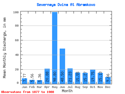
| Units: | m3/s |
| Statistic | Jan | Feb | Mar | Apr | May | Jun | Jul | Aug | Sep | Oct | Nov | Dec | Annual |
|---|---|---|---|---|---|---|---|---|---|---|---|---|---|
| Mean | 7.77 | 5.61 | 5.36 | 20.88 | 98.78 | 48.50 | 21.23 | 15.55 | 15.27 | 19.75 | 15.13 | 9.66 | 276.44 |
| Standard Deviation | 2.10 | 1.41 | 1.20 | 14.76 | 26.61 | 21.37 | 7.34 | 7.27 | 8.61 | 9.20 | 8.37 | 3.00 | 51.18 |
| Min | 3.41 | 3.03 | 3.41 | 3.06 | 37.49 | 14.02 | 7.68 | 3.80 | 1.50 | 5.61 | 4.55 | 4.19 | 155.07 |
| Max | 13.88 | 9.57 | 8.61 | 68.92 | 161.90 | 122.53 | 38.22 | 44.55 | 59.62 | 60.26 | 48.78 | 23.86 | 408.32 |
| Coefficient of Variation | 0.27 | 0.25 | 0.22 | 0.71 | 0.27 | 0.44 | 0.35 | 0.47 | 0.56 | 0.47 | 0.55 | 0.31 | 0.18 |
 Return to R-Arctic Net Home Page