|
|
|||||||||||||||||
| Point ID: 734 | Downloads | Plots | Site Data | Code: 07FD012 |
|
|
|||||||||||||||||
| Download | |
|---|---|
| Site Descriptor Information | Site Time Series Data |
| Link to all available data | |
| View: | Time Series | All |
| Units: | m3/s |
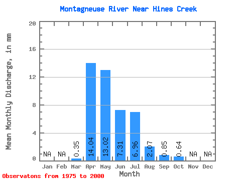
| Statistic | Jan | Feb | Mar | Apr | May | Jun | Jul | Aug | Sep | Oct | Nov | Dec | Annual |
|---|---|---|---|---|---|---|---|---|---|---|---|---|---|
| Mean | 0.35 | 14.04 | 13.02 | 7.31 | 6.97 | 2.08 | 0.84 | 0.64 | |||||
| Standard Deviation | 1.20 | 12.15 | 12.72 | 9.46 | 14.29 | 3.82 | 1.34 | 0.95 | |||||
| Min | 0.00 | 0.02 | 0.05 | 0.02 | 0.00 | 0.00 | 0.00 | 0.00 | |||||
| Max | 5.93 | 53.08 | 48.09 | 40.12 | 69.16 | 14.32 | 6.15 | 3.90 | |||||
| Coefficient of Variation | 3.44 | 0.86 | 0.98 | 1.29 | 2.05 | 1.84 | 1.59 | 1.48 |
 Return to R-Arctic Net Home Page