|
|
|||||||||||||||||
| Point ID: 7328 | Downloads | Plots | Site Data | Code: 49138 |
|
|
|||||||||||||||||
| Download | |
|---|---|
| Site Descriptor Information | Site Time Series Data |
| Link to all available data | |
| View: | Time Series | All |
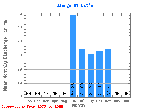
| Units: | m3/s |
| Statistic | Jan | Feb | Mar | Apr | May | Jun | Jul | Aug | Sep | Oct | Nov | Dec | Annual |
|---|---|---|---|---|---|---|---|---|---|---|---|---|---|
| Mean | 58.36 | 34.02 | 30.92 | 33.12 | 34.43 | ||||||||
| Standard Deviation | 15.55 | 10.72 | 11.32 | 12.44 | 8.32 | ||||||||
| Min | 35.80 | 19.09 | 16.37 | 16.04 | 23.23 | ||||||||
| Max | 71.12 | 57.70 | 52.77 | 56.33 | 46.51 | ||||||||
| Coefficient of Variation | 0.27 | 0.32 | 0.37 | 0.38 | 0.24 |
 Return to R-Arctic Net Home Page