|
|
|||||||||||||||||
| Point ID: 7324 | Downloads | Plots | Site Data | Code: 49130 |
|
|
|||||||||||||||||
| Download | |
|---|---|
| Site Descriptor Information | Site Time Series Data |
| Link to all available data | |
| View: | Time Series | All |
| Units: | m3/s |
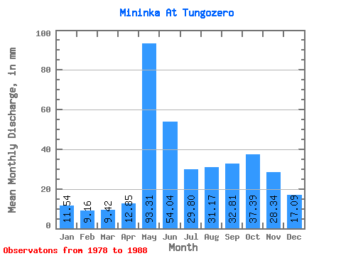
| Statistic | Jan | Feb | Mar | Apr | May | Jun | Jul | Aug | Sep | Oct | Nov | Dec | Annual |
|---|---|---|---|---|---|---|---|---|---|---|---|---|---|
| Mean | 11.54 | 9.23 | 9.42 | 12.85 | 93.29 | 54.04 | 29.79 | 31.17 | 32.82 | 37.39 | 28.35 | 17.08 | 369.72 |
| Standard Deviation | 4.52 | 2.32 | 2.00 | 6.75 | 38.02 | 21.86 | 13.44 | 21.60 | 17.39 | 16.59 | 12.23 | 5.83 | 82.17 |
| Min | 0.91 | 6.42 | 6.35 | 7.49 | 43.06 | 24.80 | 10.62 | 5.89 | 5.81 | 11.77 | 13.41 | 7.73 | 191.92 |
| Max | 17.78 | 13.46 | 12.93 | 29.72 | 169.68 | 100.78 | 56.91 | 79.65 | 67.82 | 72.84 | 59.33 | 27.59 | 465.12 |
| Coefficient of Variation | 0.39 | 0.25 | 0.21 | 0.53 | 0.41 | 0.40 | 0.45 | 0.69 | 0.53 | 0.44 | 0.43 | 0.34 | 0.22 |
 Return to R-Arctic Net Home Page