|
|
|||||||||||||||||
| Point ID: 731 | Downloads | Plots | Site Data | Code: 07FD008 |
|
|
|||||||||||||||||
| Download | |
|---|---|
| Site Descriptor Information | Site Time Series Data |
| Link to all available data | |
| View: | Time Series | All |
| Units: | m3/s |
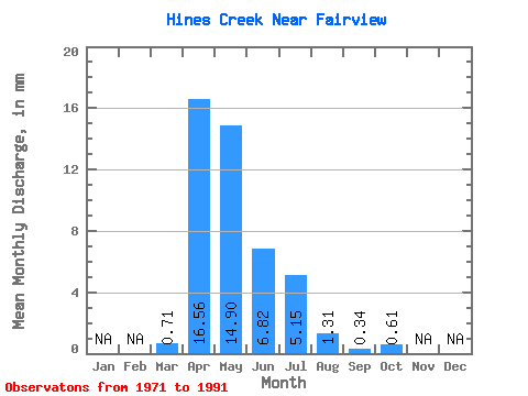
| Statistic | Jan | Feb | Mar | Apr | May | Jun | Jul | Aug | Sep | Oct | Nov | Dec | Annual |
|---|---|---|---|---|---|---|---|---|---|---|---|---|---|
| Mean | 0.68 | 15.76 | 14.18 | 6.49 | 4.90 | 1.24 | 0.32 | 0.58 | |||||
| Standard Deviation | 1.33 | 20.03 | 14.61 | 6.61 | 9.19 | 1.93 | 0.68 | 0.97 | |||||
| Min | 0.00 | 0.83 | 0.23 | 0.35 | 0.01 | 0.00 | 0.00 | 0.00 | |||||
| Max | 5.46 | 91.56 | 63.93 | 26.76 | 40.39 | 7.15 | 2.28 | 3.54 | |||||
| Coefficient of Variation | 1.96 | 1.27 | 1.03 | 1.02 | 1.88 | 1.55 | 2.08 | 1.68 |
 Return to R-Arctic Net Home Page