|
|
|||||||||||||||||
| Point ID: 7296 | Downloads | Plots | Site Data | Code: 49067 |
|
|
|||||||||||||||||
| Download | |
|---|---|
| Site Descriptor Information | Site Time Series Data |
| Link to all available data | |
| View: | Time Series | All |
| Units: | m3/s |
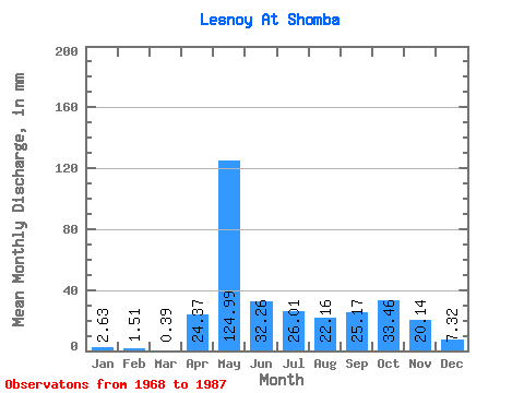
| Statistic | Jan | Feb | Mar | Apr | May | Jun | Jul | Aug | Sep | Oct | Nov | Dec | Annual |
|---|---|---|---|---|---|---|---|---|---|---|---|---|---|
| Mean | 2.63 | 1.50 | 0.39 | 24.35 | 124.96 | 32.25 | 26.03 | 22.19 | 25.20 | 33.47 | 20.15 | 7.35 | 212.80 |
| Standard Deviation | 4.47 | 2.60 | 0.71 | 31.10 | 37.95 | 27.34 | 35.59 | 28.80 | 17.61 | 30.91 | 18.28 | 9.52 | 23.82 |
| Min | 0.00 | 0.00 | 0.00 | 1.06 | 65.50 | 1.80 | 0.00 | 0.00 | 1.12 | 2.06 | 0.06 | 0.32 | 195.96 |
| Max | 11.56 | 4.51 | 2.25 | 97.59 | 190.74 | 106.29 | 104.68 | 100.83 | 65.27 | 140.00 | 59.67 | 32.75 | 229.64 |
| Coefficient of Variation | 1.70 | 1.73 | 1.82 | 1.28 | 0.30 | 0.85 | 1.37 | 1.30 | 0.70 | 0.92 | 0.91 | 1.30 | 0.11 |
 Return to R-Arctic Net Home Page