|
|
|||||||||||||||||
| Point ID: 7291 | Downloads | Plots | Site Data | Code: 49055 |
|
|
|||||||||||||||||
| Download | |
|---|---|
| Site Descriptor Information | Site Time Series Data |
| Link to all available data | |
| View: | Time Series | All |
| Units: | m3/s |
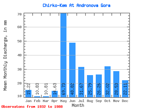
| Statistic | Jan | Feb | Mar | Apr | May | Jun | Jul | Aug | Sep | Oct | Nov | Dec | Annual |
|---|---|---|---|---|---|---|---|---|---|---|---|---|---|
| Mean | 15.22 | 10.93 | 10.81 | 14.63 | 69.72 | 48.82 | 31.66 | 25.78 | 26.26 | 32.02 | 28.53 | 22.11 | 337.23 |
| Standard Deviation | 4.93 | 3.17 | 2.91 | 7.61 | 21.90 | 15.03 | 17.95 | 16.00 | 15.36 | 16.41 | 13.85 | 8.35 | 86.37 |
| Min | 6.06 | 4.95 | 5.79 | 5.00 | 19.91 | 27.72 | 12.36 | 6.86 | 6.87 | 8.25 | 8.24 | 7.31 | 169.61 |
| Max | 26.39 | 17.16 | 16.28 | 41.11 | 108.89 | 92.10 | 90.64 | 68.77 | 70.16 | 83.87 | 69.69 | 46.40 | 531.59 |
| Coefficient of Variation | 0.32 | 0.29 | 0.27 | 0.52 | 0.31 | 0.31 | 0.57 | 0.62 | 0.58 | 0.51 | 0.48 | 0.38 | 0.26 |
 Return to R-Arctic Net Home Page