|
|
|||||||||||||||||
| Point ID: 7289 | Downloads | Plots | Site Data | Code: 49053 |
|
|
|||||||||||||||||
| Download | |
|---|---|
| Site Descriptor Information | Site Time Series Data |
| Link to all available data | |
| View: | Time Series | All |
| Units: | m3/s |
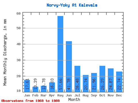
| Statistic | Jan | Feb | Mar | Apr | May | Jun | Jul | Aug | Sep | Oct | Nov | Dec | Annual |
|---|---|---|---|---|---|---|---|---|---|---|---|---|---|
| Mean | 17.60 | 13.51 | 13.79 | 16.03 | 57.63 | 41.80 | 26.46 | 20.74 | 21.98 | 26.39 | 24.87 | 22.75 | 302.81 |
| Standard Deviation | 4.27 | 4.04 | 3.40 | 4.82 | 15.69 | 9.03 | 8.67 | 8.62 | 8.64 | 7.75 | 8.99 | 6.50 | 54.08 |
| Min | 10.00 | 7.92 | 6.96 | 7.57 | 32.17 | 28.61 | 12.17 | 9.13 | 8.84 | 13.04 | 13.04 | 13.04 | 204.08 |
| Max | 24.78 | 24.95 | 19.13 | 28.19 | 89.12 | 58.07 | 46.95 | 45.65 | 42.92 | 38.69 | 50.07 | 39.13 | 385.11 |
| Coefficient of Variation | 0.24 | 0.30 | 0.25 | 0.30 | 0.27 | 0.22 | 0.33 | 0.42 | 0.39 | 0.29 | 0.36 | 0.29 | 0.18 |
 Return to R-Arctic Net Home Page