|
|
|||||||||||||||||
| Point ID: 7280 | Downloads | Plots | Site Data | Other Close Sites | Code: 49036 |
|
|
|||||||||||||||||
| Download | |
|---|---|
| Site Descriptor Information | Site Time Series Data |
| Link to all available data | |
| View: | Time Series | All |
| Units: | m3/s |
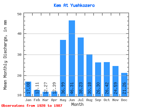
| Statistic | Jan | Feb | Mar | Apr | May | Jun | Jul | Aug | Sep | Oct | Nov | Dec | Annual |
|---|---|---|---|---|---|---|---|---|---|---|---|---|---|
| Mean | 17.07 | 13.22 | 12.27 | 12.39 | 36.98 | 46.30 | 38.22 | 30.17 | 26.30 | 26.41 | 24.59 | 21.26 | 303.80 |
| Standard Deviation | 5.56 | 4.64 | 3.85 | 4.76 | 12.64 | 15.07 | 12.13 | 9.41 | 9.59 | 10.22 | 10.66 | 8.18 | 69.63 |
| Min | 5.74 | 3.40 | 4.75 | 5.38 | 13.93 | 17.02 | 20.83 | 14.47 | 9.82 | 8.78 | 6.70 | 6.06 | 123.19 |
| Max | 29.35 | 24.89 | 22.59 | 25.53 | 61.41 | 72.52 | 67.76 | 57.08 | 50.14 | 53.15 | 53.41 | 40.71 | 449.09 |
| Coefficient of Variation | 0.33 | 0.35 | 0.31 | 0.38 | 0.34 | 0.33 | 0.32 | 0.31 | 0.36 | 0.39 | 0.43 | 0.39 | 0.23 |
| Other Close Sites | ||||||
|---|---|---|---|---|---|---|
| PointID | Latitude | Longitude | Drainage Area | Source | Name | |
| 7279 | "Kem At Yuryakhmya" | 64.83 | -2353771 | SHI | 189.00 | |
 Return to R-Arctic Net Home Page