|
|
|||||||||||||||||
| Point ID: 7278 | Downloads | Plots | Site Data | Code: 49033 |
|
|
|||||||||||||||||
| Download | |
|---|---|
| Site Descriptor Information | Site Time Series Data |
| Link to all available data | |
| View: | Time Series | All |
| Units: | m3/s |
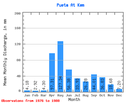
| Statistic | Jan | Feb | Mar | Apr | May | Jun | Jul | Aug | Sep | Oct | Nov | Dec | Annual |
|---|---|---|---|---|---|---|---|---|---|---|---|---|---|
| Mean | 4.18 | 2.93 | 4.28 | 97.30 | 127.33 | 56.37 | 33.90 | 26.29 | 44.02 | 36.81 | 18.68 | 7.21 | 458.40 |
| Standard Deviation | 2.93 | 1.04 | 1.30 | 74.27 | 82.37 | 79.64 | 61.27 | 36.29 | 51.39 | 27.11 | 12.73 | 4.18 | 260.48 |
| Min | 1.12 | 1.42 | 2.84 | 3.94 | 20.64 | 5.94 | 2.06 | 2.68 | 2.54 | 3.79 | 3.29 | 2.51 | 256.31 |
| Max | 12.83 | 5.03 | 7.25 | 239.76 | 300.72 | 294.84 | 218.15 | 138.36 | 193.32 | 98.75 | 40.50 | 17.30 | 1275.49 |
| Coefficient of Variation | 0.70 | 0.35 | 0.30 | 0.76 | 0.65 | 1.41 | 1.81 | 1.38 | 1.17 | 0.74 | 0.68 | 0.58 | 0.57 |
 Return to R-Arctic Net Home Page