|
|
|||||||||||||||||
| Point ID: 7277 | Downloads | Plots | Site Data | Code: 49032 |
|
|
|||||||||||||||||
| Download | |
|---|---|
| Site Descriptor Information | Site Time Series Data |
| Link to all available data | |
| View: | Time Series | All |
| Units: | m3/s |
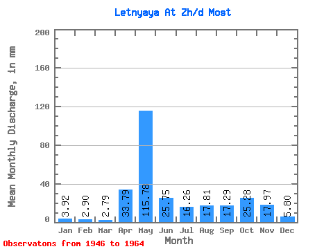
| Statistic | Jan | Feb | Mar | Apr | May | Jun | Jul | Aug | Sep | Oct | Nov | Dec | Annual |
|---|---|---|---|---|---|---|---|---|---|---|---|---|---|
| Mean | 3.92 | 2.93 | 2.79 | 33.78 | 115.77 | 25.75 | 16.26 | 17.81 | 17.29 | 25.28 | 17.97 | 5.80 | 293.12 |
| Standard Deviation | 1.97 | 1.54 | 0.99 | 48.53 | 63.94 | 17.52 | 22.61 | 25.64 | 12.91 | 16.39 | 10.68 | 3.34 | 123.72 |
| Min | 2.02 | 1.20 | 1.35 | 1.54 | 24.63 | 3.98 | 2.70 | 1.26 | 2.67 | 2.98 | 3.80 | 2.12 | 147.44 |
| Max | 8.34 | 6.46 | 4.51 | 147.86 | 211.97 | 59.98 | 95.09 | 90.19 | 54.33 | 65.95 | 37.41 | 11.63 | 486.75 |
| Coefficient of Variation | 0.50 | 0.53 | 0.35 | 1.44 | 0.55 | 0.68 | 1.39 | 1.44 | 0.75 | 0.65 | 0.59 | 0.58 | 0.42 |
 Return to R-Arctic Net Home Page