|
|
|||||||||||||||||
| Point ID: 7259 | Downloads | Plots | Site Data | Code: 12611 |
|
|
|||||||||||||||||
| Download | |
|---|---|
| Site Descriptor Information | Site Time Series Data |
| Link to all available data | |
| View: | Time Series | All |
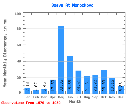
| Units: | m3/s |
| Statistic | Jan | Feb | Mar | Apr | May | Jun | Jul | Aug | Sep | Oct | Nov | Dec | Annual |
|---|---|---|---|---|---|---|---|---|---|---|---|---|---|
| Mean | 7.13 | 4.71 | 5.45 | 17.53 | 83.04 | 46.58 | 28.60 | 21.60 | 23.22 | 28.93 | 19.16 | 9.26 | 308.09 |
| Standard Deviation | 8.16 | 3.98 | 3.75 | 9.27 | 47.15 | 57.01 | 26.68 | 12.46 | 20.76 | 32.41 | 33.66 | 10.94 | 271.00 |
| Min | 3.63 | 2.69 | 2.79 | 6.74 | 42.38 | 16.07 | 6.85 | 11.43 | 6.24 | 6.29 | 5.43 | 4.52 | 152.59 |
| Max | 30.27 | 16.57 | 15.21 | 38.54 | 202.36 | 207.36 | 89.66 | 41.92 | 77.53 | 109.22 | 114.50 | 40.05 | 962.74 |
| Coefficient of Variation | 1.14 | 0.85 | 0.69 | 0.53 | 0.57 | 1.22 | 0.93 | 0.58 | 0.89 | 1.12 | 1.76 | 1.18 | 0.88 |
 Return to R-Arctic Net Home Page