|
|
|||||||||||||||||
| Point ID: 7251 | Downloads | Plots | Site Data | Code: 12532 |
|
|
|||||||||||||||||
| Download | |
|---|---|
| Site Descriptor Information | Site Time Series Data |
| Link to all available data | |
| View: | Time Series | All |
| Units: | m3/s |
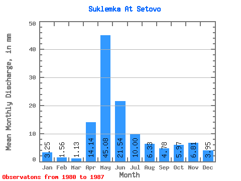
| Statistic | Jan | Feb | Mar | Apr | May | Jun | Jul | Aug | Sep | Oct | Nov | Dec | Annual |
|---|---|---|---|---|---|---|---|---|---|---|---|---|---|
| Mean | 3.25 | 1.57 | 1.13 | 14.13 | 45.07 | 21.54 | 9.99 | 6.33 | 4.78 | 5.97 | 6.81 | 3.95 | 152.55 |
| Standard Deviation | 3.15 | 1.26 | 0.78 | 11.02 | 28.50 | 11.36 | 7.46 | 4.50 | 2.88 | 5.46 | 7.78 | 4.14 | 52.70 |
| Min | 0.77 | 0.30 | 0.26 | 3.26 | 9.58 | 7.81 | 1.06 | 0.38 | 1.80 | 2.84 | 2.49 | 1.06 | 77.36 |
| Max | 9.49 | 3.39 | 2.39 | 31.76 | 91.34 | 41.37 | 20.04 | 11.88 | 9.78 | 17.03 | 22.57 | 12.15 | 191.59 |
| Coefficient of Variation | 0.97 | 0.80 | 0.69 | 0.78 | 0.63 | 0.53 | 0.75 | 0.71 | 0.60 | 0.92 | 1.14 | 1.05 | 0.34 |
 Return to R-Arctic Net Home Page