|
|
|||||||||||||||||
| Point ID: 7238 | Downloads | Plots | Site Data | Code: 12420 |
|
|
|||||||||||||||||
| Download | |
|---|---|
| Site Descriptor Information | Site Time Series Data |
| Link to all available data | |
| View: | Time Series | All |
| Units: | m3/s |
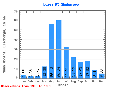
| Statistic | Jan | Feb | Mar | Apr | May | Jun | Jul | Aug | Sep | Oct | Nov | Dec | Annual |
|---|---|---|---|---|---|---|---|---|---|---|---|---|---|
| Mean | 3.68 | 2.58 | 2.71 | 12.38 | 56.12 | 60.34 | 32.30 | 21.98 | 17.02 | 17.82 | 8.91 | 5.22 | 246.85 |
| Standard Deviation | 1.02 | 0.64 | 0.82 | 8.92 | 17.46 | 29.30 | 25.38 | 17.09 | 12.90 | 13.85 | 5.49 | 1.65 | 87.74 |
| Min | 1.70 | 1.29 | 1.43 | 3.87 | 35.29 | 16.03 | 11.69 | 10.34 | 6.46 | 6.13 | 3.85 | 3.39 | 159.21 |
| Max | 5.05 | 3.47 | 4.61 | 31.31 | 81.89 | 101.43 | 89.63 | 55.57 | 43.90 | 52.94 | 21.13 | 7.91 | 385.39 |
| Coefficient of Variation | 0.28 | 0.25 | 0.30 | 0.72 | 0.31 | 0.49 | 0.79 | 0.78 | 0.76 | 0.78 | 0.62 | 0.32 | 0.35 |
 Return to R-Arctic Net Home Page