|
|
|||||||||||||||||
| Point ID: 7237 | Downloads | Plots | Site Data | Code: 12417 |
|
|
|||||||||||||||||
| Download | |
|---|---|
| Site Descriptor Information | Site Time Series Data |
| Link to all available data | |
| View: | Time Series | All |
| Units: | m3/s |
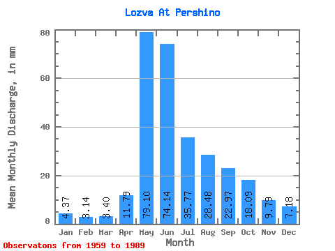
| Statistic | Jan | Feb | Mar | Apr | May | Jun | Jul | Aug | Sep | Oct | Nov | Dec | Annual |
|---|---|---|---|---|---|---|---|---|---|---|---|---|---|
| Mean | 4.37 | 3.17 | 3.40 | 11.79 | 79.09 | 74.14 | 35.77 | 28.47 | 22.97 | 18.08 | 9.79 | 7.18 | 299.39 |
| Standard Deviation | 1.27 | 0.91 | 1.08 | 10.13 | 25.81 | 34.87 | 20.61 | 17.58 | 10.39 | 8.92 | 4.07 | 2.98 | 64.53 |
| Min | 2.13 | 1.62 | 1.65 | 3.44 | 37.73 | 23.34 | 7.26 | 7.59 | 7.98 | 6.73 | 2.97 | 2.75 | 228.95 |
| Max | 7.59 | 5.61 | 6.64 | 47.63 | 136.98 | 148.46 | 91.45 | 80.38 | 47.63 | 38.59 | 21.20 | 15.67 | 437.68 |
| Coefficient of Variation | 0.29 | 0.29 | 0.32 | 0.86 | 0.33 | 0.47 | 0.58 | 0.62 | 0.45 | 0.49 | 0.41 | 0.41 | 0.22 |
 Return to R-Arctic Net Home Page