|
|
|||||||||||||||||
| Point ID: 7227 | Downloads | Plots | Site Data | Code: 12382 |
|
|
|||||||||||||||||
| Download | |
|---|---|
| Site Descriptor Information | Site Time Series Data |
| Link to all available data | |
| View: | Time Series | All |
| Units: | m3/s |
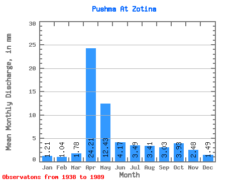
| Statistic | Jan | Feb | Mar | Apr | May | Jun | Jul | Aug | Sep | Oct | Nov | Dec | Annual |
|---|---|---|---|---|---|---|---|---|---|---|---|---|---|
| Mean | 1.21 | 1.05 | 1.78 | 24.21 | 12.43 | 4.17 | 3.49 | 3.41 | 3.03 | 3.93 | 2.48 | 1.49 | 63.03 |
| Standard Deviation | 0.63 | 0.54 | 1.10 | 13.90 | 11.31 | 2.40 | 2.76 | 3.66 | 3.10 | 4.84 | 2.25 | 0.84 | 31.73 |
| Min | 0.35 | 0.40 | 0.26 | 4.08 | 0.82 | 0.97 | 0.77 | 0.70 | 0.57 | 0.67 | 0.66 | 0.42 | 16.70 |
| Max | 2.68 | 2.59 | 4.89 | 54.43 | 53.07 | 9.10 | 14.85 | 19.89 | 17.13 | 22.89 | 10.51 | 3.99 | 162.18 |
| Coefficient of Variation | 0.52 | 0.51 | 0.62 | 0.57 | 0.91 | 0.58 | 0.79 | 1.07 | 1.02 | 1.23 | 0.91 | 0.57 | 0.50 |
 Return to R-Arctic Net Home Page