|
|
|||||||||||||||||
| Point ID: 7224 | Downloads | Plots | Site Data | Code: 12354 |
|
|
|||||||||||||||||
| Download | |
|---|---|
| Site Descriptor Information | Site Time Series Data |
| Link to all available data | |
| View: | Time Series | All |
| Units: | m3/s |
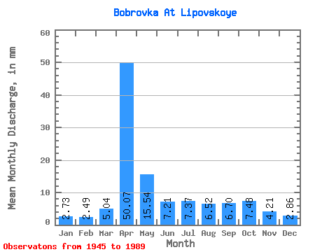
| Statistic | Jan | Feb | Mar | Apr | May | Jun | Jul | Aug | Sep | Oct | Nov | Dec | Annual |
|---|---|---|---|---|---|---|---|---|---|---|---|---|---|
| Mean | 2.73 | 2.50 | 5.04 | 50.07 | 15.53 | 7.21 | 7.38 | 6.52 | 6.69 | 7.49 | 4.21 | 2.87 | 118.61 |
| Standard Deviation | 1.78 | 1.71 | 4.25 | 28.49 | 11.35 | 3.89 | 5.39 | 4.33 | 6.36 | 5.90 | 2.63 | 1.78 | 46.01 |
| Min | 0.34 | 0.41 | 0.32 | 8.73 | 2.92 | 1.08 | 0.98 | 0.77 | 1.13 | 1.38 | 0.77 | 0.19 | 41.20 |
| Max | 8.22 | 8.21 | 22.80 | 149.36 | 64.70 | 17.45 | 24.13 | 23.07 | 40.80 | 30.23 | 12.32 | 7.95 | 247.38 |
| Coefficient of Variation | 0.65 | 0.68 | 0.84 | 0.57 | 0.73 | 0.54 | 0.73 | 0.66 | 0.95 | 0.79 | 0.62 | 0.62 | 0.39 |
 Return to R-Arctic Net Home Page