|
|
|||||||||||||||||
| Point ID: 7223 | Downloads | Plots | Site Data | Code: 12346 |
|
|
|||||||||||||||||
| Download | |
|---|---|
| Site Descriptor Information | Site Time Series Data |
| Link to all available data | |
| View: | Time Series | All |
| Units: | m3/s |
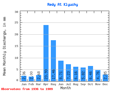
| Statistic | Jan | Feb | Mar | Apr | May | Jun | Jul | Aug | Sep | Oct | Nov | Dec | Annual |
|---|---|---|---|---|---|---|---|---|---|---|---|---|---|
| Mean | 2.37 | 2.02 | 2.67 | 23.93 | 17.45 | 8.71 | 7.23 | 6.16 | 5.83 | 6.46 | 4.76 | 2.85 | 90.87 |
| Standard Deviation | 1.01 | 0.75 | 1.06 | 13.22 | 11.05 | 4.42 | 5.93 | 5.79 | 6.69 | 7.55 | 5.28 | 1.63 | 42.19 |
| Min | 0.85 | 0.70 | 1.17 | 1.86 | 3.21 | 1.97 | 1.58 | 1.73 | 1.56 | 1.52 | 1.12 | 0.98 | 30.44 |
| Max | 5.39 | 4.27 | 5.30 | 57.02 | 60.86 | 24.86 | 33.78 | 28.55 | 34.52 | 37.55 | 36.35 | 11.02 | 220.68 |
| Coefficient of Variation | 0.43 | 0.37 | 0.40 | 0.55 | 0.63 | 0.51 | 0.82 | 0.94 | 1.15 | 1.17 | 1.11 | 0.57 | 0.46 |
 Return to R-Arctic Net Home Page