|
|
|||||||||||||||||
| Point ID: 7214 | Downloads | Plots | Site Data | Code: 12276 |
|
|
|||||||||||||||||
| Download | |
|---|---|
| Site Descriptor Information | Site Time Series Data |
| Link to all available data | |
| View: | Time Series | All |
| Units: | m3/s |
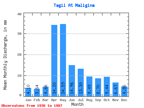
| Statistic | Jan | Feb | Mar | Apr | May | Jun | Jul | Aug | Sep | Oct | Nov | Dec | Annual |
|---|---|---|---|---|---|---|---|---|---|---|---|---|---|
| Mean | 4.10 | 3.67 | 4.66 | 34.20 | 34.58 | 14.96 | 13.30 | 9.49 | 8.70 | 9.44 | 6.67 | 4.86 | 148.42 |
| Standard Deviation | 1.83 | 1.80 | 2.24 | 18.56 | 22.98 | 13.07 | 11.95 | 7.10 | 6.10 | 7.96 | 4.65 | 2.76 | 51.70 |
| Min | 2.07 | 1.56 | 2.00 | 6.01 | 6.85 | 3.87 | 3.24 | 2.95 | 2.81 | 2.50 | 1.73 | 1.85 | 64.19 |
| Max | 8.52 | 9.70 | 10.44 | 76.43 | 93.39 | 65.73 | 49.99 | 33.92 | 24.86 | 38.32 | 22.00 | 11.33 | 258.97 |
| Coefficient of Variation | 0.45 | 0.49 | 0.48 | 0.54 | 0.66 | 0.87 | 0.90 | 0.75 | 0.70 | 0.84 | 0.70 | 0.57 | 0.35 |
 Return to R-Arctic Net Home Page