|
|
|||||||||||||||||
| Point ID: 7208 | Downloads | Plots | Site Data | Code: 12225 |
|
|
|||||||||||||||||
| Download | |
|---|---|
| Site Descriptor Information | Site Time Series Data |
| Link to all available data | |
| View: | Time Series | All |
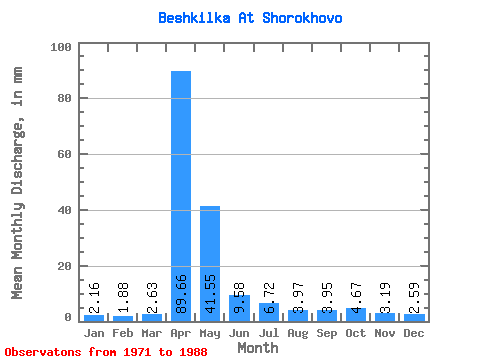
| Units: | m3/s |
| Statistic | Jan | Feb | Mar | Apr | May | Jun | Jul | Aug | Sep | Oct | Nov | Dec | Annual |
|---|---|---|---|---|---|---|---|---|---|---|---|---|---|
| Mean | 2.15 | 1.89 | 2.61 | 89.64 | 41.53 | 9.57 | 6.70 | 3.96 | 3.95 | 4.67 | 3.18 | 2.58 | 189.22 |
| Standard Deviation | 0.76 | 0.66 | 1.53 | 85.17 | 41.51 | 9.25 | 11.07 | 5.06 | 3.06 | 2.90 | 2.43 | 1.57 | 132.11 |
| Min | 0.75 | 0.86 | 1.18 | 12.54 | 7.85 | 1.90 | 1.14 | 0.79 | 0.76 | 0.98 | 0.95 | 1.30 | 52.79 |
| Max | 3.81 | 2.90 | 7.07 | 271.36 | 131.54 | 30.02 | 48.30 | 22.38 | 11.02 | 11.39 | 10.26 | 7.46 | 403.83 |
| Coefficient of Variation | 0.35 | 0.35 | 0.58 | 0.95 | 1.00 | 0.97 | 1.65 | 1.28 | 0.77 | 0.62 | 0.76 | 0.61 | 0.70 |
 Return to R-Arctic Net Home Page