|
|
|||||||||||||||||
| Point ID: 7195 | Downloads | Plots | Site Data | Code: 12166 |
|
|
|||||||||||||||||
| Download | |
|---|---|
| Site Descriptor Information | Site Time Series Data |
| Link to all available data | |
| View: | Time Series | All |
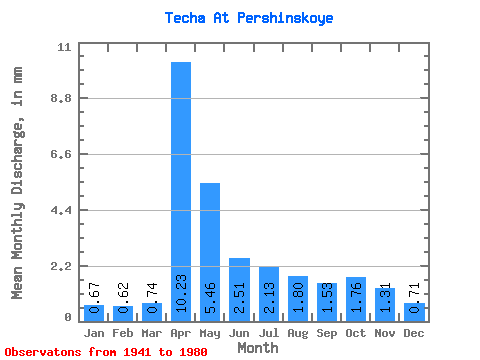
| Units: | m3/s |
| Statistic | Jan | Feb | Mar | Apr | May | Jun | Jul | Aug | Sep | Oct | Nov | Dec | Annual |
|---|---|---|---|---|---|---|---|---|---|---|---|---|---|
| Mean | 0.67 | 0.63 | 0.74 | 10.23 | 5.46 | 2.51 | 2.13 | 1.80 | 1.53 | 1.76 | 1.31 | 0.71 | 29.51 |
| Standard Deviation | 0.64 | 0.73 | 0.83 | 9.69 | 6.00 | 2.76 | 3.17 | 1.99 | 1.53 | 2.27 | 2.10 | 0.67 | 27.19 |
| Min | 0.11 | 0.08 | 0.09 | 0.99 | 0.50 | 0.21 | 0.18 | 0.15 | 0.13 | 0.12 | 0.16 | 0.12 | 2.92 |
| Max | 2.23 | 3.50 | 3.80 | 37.50 | 29.83 | 13.47 | 17.49 | 9.29 | 6.26 | 11.85 | 11.03 | 2.42 | 110.97 |
| Coefficient of Variation | 0.95 | 1.16 | 1.13 | 0.95 | 1.10 | 1.10 | 1.49 | 1.10 | 1.00 | 1.29 | 1.61 | 0.95 | 0.92 |
 Return to R-Arctic Net Home Page