|
|
|||||||||||||||||
| Point ID: 7189 | Downloads | Plots | Site Data | Code: 12138 |
|
|
|||||||||||||||||
| Download | |
|---|---|
| Site Descriptor Information | Site Time Series Data |
| Link to all available data | |
| View: | Time Series | All |
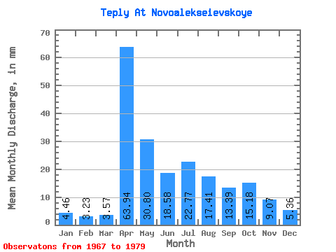
| Units: | m3/s |
| Statistic | Jan | Feb | Mar | Apr | May | Jun | Jul | Aug | Sep | Oct | Nov | Dec | Annual |
|---|---|---|---|---|---|---|---|---|---|---|---|---|---|
| Mean | 4.33 | 3.33 | 3.53 | 63.98 | 30.89 | 18.36 | 22.63 | 17.45 | 13.44 | 15.35 | 9.03 | 5.22 | 213.61 |
| Standard Deviation | 2.15 | 1.78 | 1.48 | 25.22 | 20.53 | 11.03 | 12.92 | 17.23 | 9.81 | 9.64 | 4.61 | 2.69 | 75.57 |
| Min | 0.45 | 0.41 | 1.34 | 23.76 | 10.71 | 2.59 | 0.89 | 4.02 | 2.59 | 2.68 | 2.59 | 2.23 | 83.28 |
| Max | 6.70 | 6.51 | 5.80 | 94.61 | 67.40 | 34.13 | 39.72 | 63.83 | 27.65 | 30.80 | 16.42 | 9.82 | 322.18 |
| Coefficient of Variation | 0.50 | 0.53 | 0.42 | 0.39 | 0.67 | 0.60 | 0.57 | 0.99 | 0.73 | 0.63 | 0.51 | 0.52 | 0.35 |
 Return to R-Arctic Net Home Page