|
|
|||||||||||||||||
| Point ID: 7184 | Downloads | Plots | Site Data | Other Close Sites | Code: 12127 |
|
|
|||||||||||||||||
| Download | |
|---|---|
| Site Descriptor Information | Site Time Series Data |
| Link to all available data | |
| View: | Time Series | All |
| Units: | m3/s |
| Statistic | Jan | Feb | Mar | Apr | May | Jun | Jul | Aug | Sep | Oct | Nov | Dec | Annual |
|---|---|---|---|---|---|---|---|---|---|---|---|---|---|
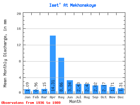
| Mean | 0.99 | 0.88 | 1.05 | 13.05 | 8.08 | 3.05 | 2.21 | 2.20 | 1.84 | 1.98 | 1.56 | 1.20 | 39.16 |
| Standard Deviation | 0.43 | 0.39 | 0.46 | 10.12 | 8.05 | 2.14 | 1.32 | 1.57 | 1.11 | 1.53 | 1.00 | 0.59 | 20.73 |
| Min | 0.29 | 0.19 | 0.19 | 1.73 | 1.31 | 0.74 | 0.48 | 0.59 | 0.43 | 0.31 | 0.62 | 0.49 | 11.34 |
| Max | 2.40 | 1.91 | 2.23 | 44.80 | 49.21 | 13.18 | 7.73 | 7.94 | 5.90 | 9.42 | 5.05 | 3.09 | 97.25 |
| Coefficient of Variation | 0.44 | 0.44 | 0.43 | 0.78 | 1.00 | 0.70 | 0.60 | 0.71 | 0.60 | 0.77 | 0.64 | 0.49 | 0.53 |
| Other Close Sites | ||||||
|---|---|---|---|---|---|---|
| PointID | Latitude | Longitude | Drainage Area | Source | Name | |
| 7202 | "Miass At Kargopol'e" | 55.95 | -1610285 | SHI | 24.00 | |
 Return to R-Arctic Net Home Page