|
|
|||||||||||||||||
| Point ID: 7178 | Downloads | Plots | Site Data | Code: 12103 |
|
|
|||||||||||||||||
| Download | |
|---|---|
| Site Descriptor Information | Site Time Series Data |
| Link to all available data | |
| View: | Time Series | All |
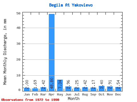
| Units: | m3/s |
| Statistic | Jan | Feb | Mar | Apr | May | Jun | Jul | Aug | Sep | Oct | Nov | Dec | Annual |
|---|---|---|---|---|---|---|---|---|---|---|---|---|---|
| Mean | 2.00 | 1.70 | 2.42 | 48.79 | 7.35 | 2.96 | 2.24 | 2.42 | 2.18 | 3.41 | 2.91 | 2.53 | 82.61 |
| Standard Deviation | 0.50 | 0.62 | 1.26 | 28.75 | 4.81 | 1.65 | 1.23 | 1.39 | 0.89 | 1.34 | 0.99 | 0.89 | 37.25 |
| Min | 1.09 | 0.22 | 0.33 | 12.54 | 2.07 | 0.79 | 0.80 | 0.69 | 0.92 | 1.90 | 1.67 | 1.07 | 30.63 |
| Max | 2.76 | 2.68 | 5.87 | 121.41 | 18.66 | 5.69 | 5.36 | 6.05 | 3.68 | 7.08 | 5.35 | 4.84 | 160.48 |
| Coefficient of Variation | 0.25 | 0.37 | 0.52 | 0.59 | 0.66 | 0.56 | 0.55 | 0.57 | 0.41 | 0.40 | 0.34 | 0.35 | 0.45 |
 Return to R-Arctic Net Home Page