|
|
|||||||||||||||||
| Point ID: 7169 | Downloads | Plots | Site Data | Code: 12071 |
|
|
|||||||||||||||||
| Download | |
|---|---|
| Site Descriptor Information | Site Time Series Data |
| Link to all available data | |
| View: | Time Series | All |
| Units: | m3/s |
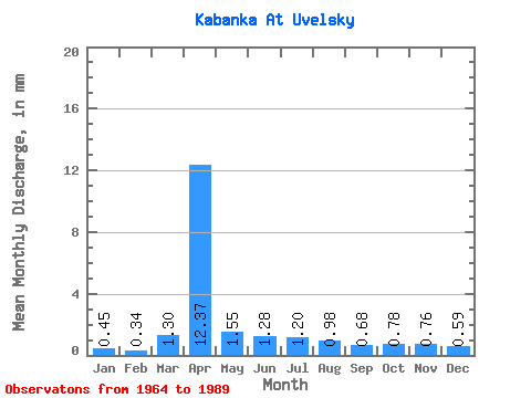
| Statistic | Jan | Feb | Mar | Apr | May | Jun | Jul | Aug | Sep | Oct | Nov | Dec | Annual |
|---|---|---|---|---|---|---|---|---|---|---|---|---|---|
| Mean | 0.45 | 0.34 | 1.30 | 12.37 | 1.55 | 1.27 | 1.21 | 0.98 | 0.69 | 0.78 | 0.76 | 0.59 | 23.36 |
| Standard Deviation | 0.30 | 0.21 | 3.29 | 14.31 | 1.32 | 1.53 | 1.44 | 1.35 | 0.45 | 0.39 | 0.35 | 0.32 | 18.25 |
| Min | 0.02 | 0.05 | 0.00 | 0.86 | 0.25 | 0.12 | 0.01 | 0.01 | 0.03 | 0.10 | 0.12 | 0.11 | 2.96 |
| Max | 1.37 | 0.78 | 17.02 | 48.41 | 6.89 | 7.56 | 5.79 | 7.20 | 2.07 | 1.62 | 1.48 | 1.22 | 56.62 |
| Coefficient of Variation | 0.68 | 0.63 | 2.54 | 1.16 | 0.85 | 1.20 | 1.19 | 1.37 | 0.65 | 0.50 | 0.46 | 0.53 | 0.78 |
 Return to R-Arctic Net Home Page