|
|
|||||||||||||||||
| Point ID: 7162 | Downloads | Plots | Site Data | Code: 12043 |
|
|
|||||||||||||||||
| Download | |
|---|---|
| Site Descriptor Information | Site Time Series Data |
| Link to all available data | |
| View: | Time Series | All |
| Units: | m3/s |
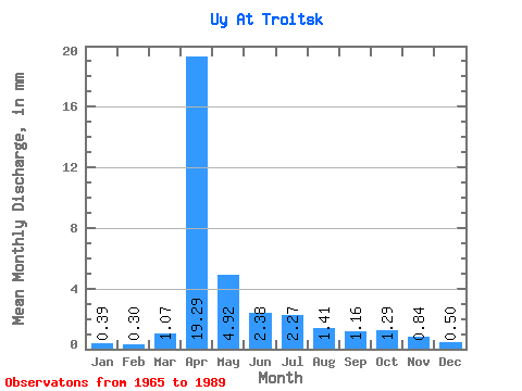
| Statistic | Jan | Feb | Mar | Apr | May | Jun | Jul | Aug | Sep | Oct | Nov | Dec | Annual |
|---|---|---|---|---|---|---|---|---|---|---|---|---|---|
| Mean | 0.39 | 0.30 | 1.06 | 19.29 | 4.92 | 2.38 | 2.27 | 1.41 | 1.16 | 1.29 | 0.84 | 0.49 | 40.02 |
| Standard Deviation | 0.22 | 0.19 | 1.49 | 14.72 | 3.58 | 1.73 | 3.10 | 1.11 | 0.76 | 0.92 | 0.45 | 0.25 | 19.83 |
| Min | 0.00 | 0.03 | 0.01 | 2.15 | 0.79 | 0.22 | 0.22 | 0.10 | 0.03 | 0.04 | 0.03 | 0.00 | 15.12 |
| Max | 0.84 | 0.78 | 5.94 | 60.91 | 14.37 | 7.14 | 15.07 | 5.10 | 3.37 | 4.69 | 1.88 | 1.14 | 89.19 |
| Coefficient of Variation | 0.57 | 0.65 | 1.40 | 0.76 | 0.73 | 0.73 | 1.36 | 0.79 | 0.65 | 0.71 | 0.53 | 0.51 | 0.50 |
 Return to R-Arctic Net Home Page