|
|
|||||||||||||||||
| Point ID: 7161 | Downloads | Plots | Site Data | Code: 12040 |
|
|
|||||||||||||||||
| Download | |
|---|---|
| Site Descriptor Information | Site Time Series Data |
| Link to all available data | |
| View: | Time Series | All |
| Units: | m3/s |
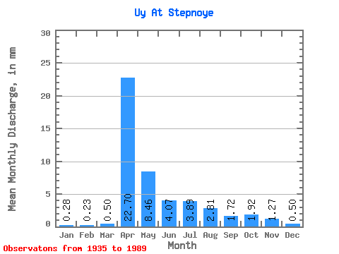
| Statistic | Jan | Feb | Mar | Apr | May | Jun | Jul | Aug | Sep | Oct | Nov | Dec | Annual |
|---|---|---|---|---|---|---|---|---|---|---|---|---|---|
| Mean | 0.28 | 0.23 | 0.50 | 22.70 | 8.46 | 4.07 | 3.89 | 2.81 | 1.72 | 1.93 | 1.27 | 0.50 | 55.10 |
| Standard Deviation | 0.24 | 0.22 | 0.93 | 18.71 | 8.55 | 4.40 | 5.59 | 3.54 | 1.71 | 1.94 | 1.17 | 0.41 | 34.83 |
| Min | 0.00 | 0.00 | 0.00 | 1.60 | 0.66 | 0.24 | 0.10 | 0.09 | 0.04 | 0.07 | 0.05 | 0.00 | 8.95 |
| Max | 0.83 | 0.87 | 5.68 | 76.32 | 48.65 | 28.94 | 29.23 | 16.96 | 8.64 | 11.75 | 5.93 | 2.02 | 146.29 |
| Coefficient of Variation | 0.86 | 0.95 | 1.84 | 0.82 | 1.01 | 1.08 | 1.44 | 1.26 | 0.99 | 1.01 | 0.92 | 0.81 | 0.63 |
 Return to R-Arctic Net Home Page