|
|
|||||||||||||||||
| Point ID: 7145 | Downloads | Plots | Site Data | Code: 11808 |
|
|
|||||||||||||||||
| Download | |
|---|---|
| Site Descriptor Information | Site Time Series Data |
| Link to all available data | |
| View: | Time Series | All |
| Units: | m3/s |
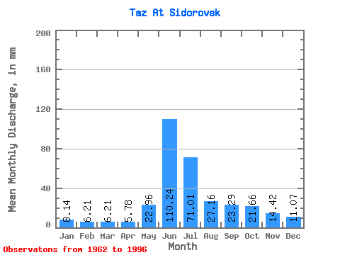
| Statistic | Jan | Feb | Mar | Apr | May | Jun | Jul | Aug | Sep | Oct | Nov | Dec | Annual |
|---|---|---|---|---|---|---|---|---|---|---|---|---|---|
| Mean | 8.14 | 6.26 | 6.21 | 5.78 | 22.95 | 110.24 | 71.00 | 27.15 | 23.29 | 21.66 | 14.42 | 11.06 | 330.23 |
| Standard Deviation | 1.92 | 1.45 | 1.80 | 2.05 | 17.00 | 21.34 | 30.34 | 9.79 | 7.50 | 7.94 | 4.92 | 3.54 | 44.05 |
| Min | 4.85 | 3.88 | 3.43 | 3.06 | 4.29 | 17.94 | 12.45 | 12.94 | 9.10 | 10.82 | 6.09 | 5.95 | 274.23 |
| Max | 12.45 | 10.42 | 11.30 | 11.07 | 69.68 | 131.67 | 144.08 | 55.17 | 44.43 | 44.08 | 27.99 | 18.64 | 465.12 |
| Coefficient of Variation | 0.23 | 0.23 | 0.29 | 0.35 | 0.74 | 0.19 | 0.43 | 0.36 | 0.32 | 0.37 | 0.34 | 0.32 | 0.13 |
 Return to R-Arctic Net Home Page