|
|
|||||||||||||||||
| Point ID: 7142 | Downloads | Plots | Site Data | Code: 11801 |
|
|
|||||||||||||||||
| Download | |
|---|---|
| Site Descriptor Information | Site Time Series Data |
| Link to all available data | |
| View: | Time Series | All |
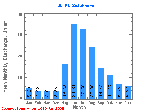
| Units: | m3/s |
| Statistic | Jan | Feb | Mar | Apr | May | Jun | Jul | Aug | Sep | Oct | Nov | Dec | Annual |
|---|---|---|---|---|---|---|---|---|---|---|---|---|---|
| Mean | 4.28 | 3.26 | 3.14 | 3.18 | 13.49 | 28.67 | 26.76 | 19.75 | 11.89 | 9.28 | 5.56 | 4.87 | 133.65 |
| Standard Deviation | 0.85 | 0.61 | 0.61 | 1.04 | 5.05 | 3.08 | 4.84 | 7.82 | 4.71 | 2.02 | 1.57 | 1.05 | 19.85 |
| Min | 2.77 | 1.98 | 1.93 | 2.07 | 4.78 | 18.89 | 12.35 | 8.31 | 5.83 | 5.50 | 2.94 | 2.84 | 90.81 |
| Max | 6.30 | 4.80 | 5.49 | 9.49 | 28.60 | 36.99 | 38.67 | 39.47 | 29.07 | 18.16 | 9.14 | 7.17 | 194.09 |
| Coefficient of Variation | 0.20 | 0.19 | 0.20 | 0.33 | 0.37 | 0.11 | 0.18 | 0.40 | 0.40 | 0.22 | 0.28 | 0.22 | 0.15 |
 Return to R-Arctic Net Home Page