|
|
|||||||||||||||||
| Point ID: 7123 | Downloads | Plots | Site Data | Code: 11587 |
|
|
|||||||||||||||||
| Download | |
|---|---|
| Site Descriptor Information | Site Time Series Data |
| Link to all available data | |
| View: | Time Series | All |
| Units: | m3/s |
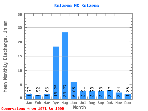
| Statistic | Jan | Feb | Mar | Apr | May | Jun | Jul | Aug | Sep | Oct | Nov | Dec | Annual |
|---|---|---|---|---|---|---|---|---|---|---|---|---|---|
| Mean | 1.77 | 1.54 | 1.66 | 18.29 | 23.27 | 6.05 | 2.91 | 2.73 | 2.73 | 3.17 | 2.35 | 1.86 | 71.83 |
| Standard Deviation | 0.46 | 0.48 | 0.49 | 17.44 | 17.06 | 3.46 | 2.13 | 1.45 | 1.63 | 1.56 | 0.78 | 0.42 | 29.56 |
| Min | 1.21 | 0.87 | 1.02 | 3.34 | 3.58 | 0.44 | 0.08 | 0.17 | 1.24 | 1.79 | 1.48 | 1.41 | 27.62 |
| Max | 2.62 | 2.33 | 2.75 | 64.95 | 57.59 | 12.74 | 9.65 | 4.99 | 6.31 | 7.16 | 3.71 | 3.00 | 110.28 |
| Coefficient of Variation | 0.26 | 0.31 | 0.30 | 0.95 | 0.73 | 0.57 | 0.73 | 0.53 | 0.60 | 0.49 | 0.33 | 0.22 | 0.41 |
 Return to R-Arctic Net Home Page