|
|
|||||||||||||||||
| Point ID: 7110 | Downloads | Plots | Site Data | Code: 11556 |
|
|
|||||||||||||||||
| Download | |
|---|---|
| Site Descriptor Information | Site Time Series Data |
| Link to all available data | |
| View: | Time Series | All |
| Units: | m3/s |
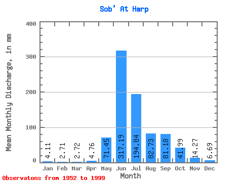
| Statistic | Jan | Feb | Mar | Apr | May | Jun | Jul | Aug | Sep | Oct | Nov | Dec | Annual |
|---|---|---|---|---|---|---|---|---|---|---|---|---|---|
| Mean | 4.11 | 2.73 | 2.72 | 4.76 | 71.44 | 317.19 | 194.81 | 82.72 | 81.18 | 41.98 | 14.27 | 6.69 | 832.99 |
| Standard Deviation | 1.65 | 1.24 | 1.15 | 10.91 | 96.31 | 108.68 | 86.62 | 40.02 | 34.06 | 20.94 | 9.43 | 2.64 | 182.43 |
| Min | 0.52 | 0.09 | 0.76 | 0.75 | 0.91 | 50.17 | 84.01 | 40.82 | 23.41 | 10.80 | 3.89 | 1.34 | 458.53 |
| Max | 7.99 | 5.06 | 6.20 | 75.67 | 360.67 | 614.55 | 488.09 | 201.28 | 173.91 | 101.72 | 56.44 | 13.46 | 1322.06 |
| Coefficient of Variation | 0.40 | 0.45 | 0.42 | 2.29 | 1.35 | 0.34 | 0.45 | 0.48 | 0.42 | 0.50 | 0.66 | 0.39 | 0.22 |
 Return to R-Arctic Net Home Page