|
|
|||||||||||||||||
| Point ID: 7078 | Downloads | Plots | Site Data | Code: 11488 |
|
|
|||||||||||||||||
| Download | |
|---|---|
| Site Descriptor Information | Site Time Series Data |
| Link to all available data | |
| View: | Time Series | All |
| Units: | m3/s |
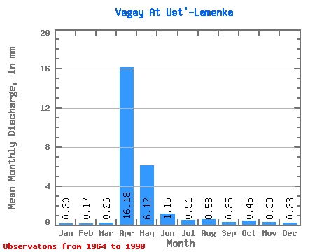
| Statistic | Jan | Feb | Mar | Apr | May | Jun | Jul | Aug | Sep | Oct | Nov | Dec | Annual |
|---|---|---|---|---|---|---|---|---|---|---|---|---|---|
| Mean | 0.20 | 0.17 | 0.26 | 16.18 | 6.12 | 1.15 | 0.51 | 0.58 | 0.35 | 0.45 | 0.33 | 0.23 | 30.07 |
| Standard Deviation | 0.07 | 0.07 | 0.14 | 15.80 | 9.35 | 1.32 | 0.54 | 0.81 | 0.28 | 0.57 | 0.30 | 0.09 | 25.73 |
| Min | 0.05 | 0.01 | 0.01 | 1.60 | 0.23 | 0.07 | 0.09 | 0.09 | 0.06 | 0.01 | 0.14 | 0.08 | 3.33 |
| Max | 0.31 | 0.28 | 0.75 | 70.18 | 41.16 | 5.65 | 2.82 | 3.87 | 1.25 | 2.92 | 1.59 | 0.39 | 99.73 |
| Coefficient of Variation | 0.35 | 0.41 | 0.56 | 0.98 | 1.53 | 1.15 | 1.05 | 1.39 | 0.79 | 1.28 | 0.89 | 0.39 | 0.86 |
 Return to R-Arctic Net Home Page