|
|
|||||||||||||||||
| Point ID: 7076 | Downloads | Plots | Site Data | Code: 11484 |
|
|
|||||||||||||||||
| Download | |
|---|---|
| Site Descriptor Information | Site Time Series Data |
| Link to all available data | |
| View: | Time Series | All |
| Units: | m3/s |
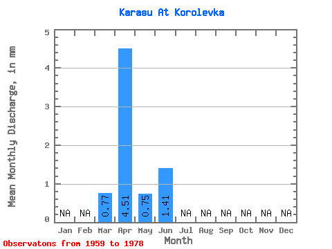
| Statistic | Jan | Feb | Mar | Apr | May | Jun | Jul | Aug | Sep | Oct | Nov | Dec | Annual |
|---|---|---|---|---|---|---|---|---|---|---|---|---|---|
| Mean | 0.77 | 4.51 | 0.74 | 1.41 | |||||||||
| Standard Deviation | 7.38 | 1.65 | |||||||||||
| Min | 0.77 | 0.03 | 0.01 | 1.41 | |||||||||
| Max | 0.77 | 25.26 | 4.11 | 1.41 | |||||||||
| Coefficient of Variation | 1.64 | 2.22 |
 Return to R-Arctic Net Home Page