|
|
|||||||||||||||||
| Point ID: 7059 | Downloads | Plots | Site Data | Code: 11415 |
|
|
|||||||||||||||||
| Download | |
|---|---|
| Site Descriptor Information | Site Time Series Data |
| Link to all available data | |
| View: | Time Series | All |
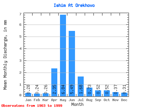
| Units: | m3/s |
| Statistic | Jan | Feb | Mar | Apr | May | Jun | Jul | Aug | Sep | Oct | Nov | Dec | Annual |
|---|---|---|---|---|---|---|---|---|---|---|---|---|---|
| Mean | 0.24 | 0.20 | 0.22 | 1.98 | 5.76 | 4.62 | 1.42 | 0.61 | 0.44 | 0.43 | 0.31 | 0.26 | 16.60 |
| Standard Deviation | 0.10 | 0.09 | 0.10 | 1.33 | 2.93 | 3.57 | 1.19 | 0.41 | 0.21 | 0.21 | 0.13 | 0.10 | 8.79 |
| Min | 0.06 | 0.04 | 0.04 | 0.17 | 0.32 | 0.14 | 0.09 | 0.12 | 0.09 | 0.09 | 0.04 | 0.06 | 1.35 |
| Max | 0.47 | 0.34 | 0.41 | 6.07 | 10.95 | 11.68 | 5.44 | 2.25 | 1.12 | 0.88 | 0.59 | 0.53 | 34.72 |
| Coefficient of Variation | 0.42 | 0.43 | 0.46 | 0.67 | 0.51 | 0.77 | 0.84 | 0.66 | 0.49 | 0.48 | 0.42 | 0.40 | 0.53 |
 Return to R-Arctic Net Home Page