|
|
|||||||||||||||||
| Point ID: 7050 | Downloads | Plots | Site Data | Code: 11402 |
|
|
|||||||||||||||||
| Download | |
|---|---|
| Site Descriptor Information | Site Time Series Data |
| Link to all available data | |
| View: | Time Series | All |
| Units: | m3/s |
| Statistic | Jan | Feb | Mar | Apr | May | Jun | Jul | Aug | Sep | Oct | Nov | Dec | Annual |
|---|---|---|---|---|---|---|---|---|---|---|---|---|---|
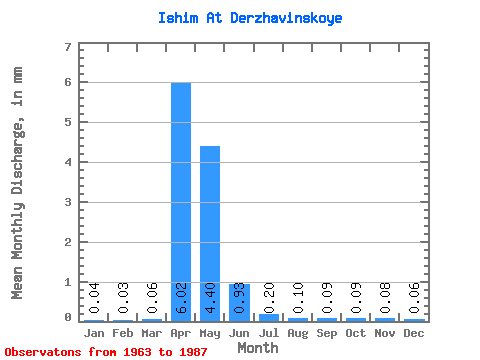
| Mean | 0.04 | 0.03 | 0.06 | 6.02 | 4.40 | 0.93 | 0.20 | 0.10 | 0.09 | 0.09 | 0.08 | 0.06 | 13.14 |
| Standard Deviation | 0.03 | 0.02 | 0.07 | 4.64 | 4.76 | 0.91 | 0.18 | 0.06 | 0.06 | 0.06 | 0.05 | 0.04 | 10.29 |
| Min | 0.00 | 0.00 | 0.01 | 0.34 | 0.27 | 0.05 | 0.01 | 0.00 | 0.00 | 0.01 | 0.01 | 0.00 | 0.79 |
| Max | 0.12 | 0.09 | 0.37 | 13.88 | 20.51 | 3.15 | 0.67 | 0.32 | 0.24 | 0.26 | 0.20 | 0.16 | 35.19 |
| Coefficient of Variation | 0.65 | 0.69 | 1.34 | 0.77 | 1.08 | 0.98 | 0.90 | 0.67 | 0.66 | 0.63 | 0.67 | 0.72 | 0.78 |
 Return to R-Arctic Net Home Page