|
|
|||||||||||||||||
| Point ID: 7045 | Downloads | Plots | Site Data | Code: 11386 |
|
|
|||||||||||||||||
| Download | |
|---|---|
| Site Descriptor Information | Site Time Series Data |
| Link to all available data | |
| View: | Time Series | All |
| Units: | m3/s |
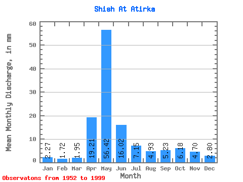
| Statistic | Jan | Feb | Mar | Apr | May | Jun | Jul | Aug | Sep | Oct | Nov | Dec | Annual |
|---|---|---|---|---|---|---|---|---|---|---|---|---|---|
| Mean | 2.27 | 1.74 | 1.96 | 19.21 | 56.41 | 16.02 | 7.14 | 4.93 | 5.23 | 6.18 | 4.70 | 2.80 | 128.13 |
| Standard Deviation | 0.69 | 0.48 | 0.56 | 14.18 | 30.30 | 12.53 | 7.13 | 3.69 | 3.82 | 4.04 | 3.13 | 0.92 | 48.48 |
| Min | 0.87 | 0.63 | 0.94 | 2.16 | 6.28 | 3.42 | 1.51 | 1.39 | 1.65 | 1.59 | 1.38 | 1.06 | 36.70 |
| Max | 3.72 | 3.12 | 3.07 | 57.58 | 128.54 | 62.90 | 37.35 | 22.21 | 17.97 | 17.64 | 17.97 | 5.02 | 234.14 |
| Coefficient of Variation | 0.31 | 0.28 | 0.29 | 0.74 | 0.54 | 0.78 | 1.00 | 0.75 | 0.73 | 0.66 | 0.67 | 0.33 | 0.38 |
 Return to R-Arctic Net Home Page