|
|
|||||||||||||||||
| Point ID: 7039 | Downloads | Plots | Site Data | Code: 11374 |
|
|
|||||||||||||||||
| Download | |
|---|---|
| Site Descriptor Information | Site Time Series Data |
| Link to all available data | |
| View: | Time Series | All |
| Units: | m3/s |
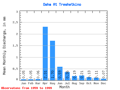
| Statistic | Jan | Feb | Mar | Apr | May | Jun | Jul | Aug | Sep | Oct | Nov | Dec | Annual |
|---|---|---|---|---|---|---|---|---|---|---|---|---|---|
| Mean | 0.05 | 0.05 | 0.06 | 2.31 | 1.70 | 0.59 | 0.36 | 0.19 | 0.21 | 0.13 | 0.11 | 0.07 | 6.65 |
| Standard Deviation | 0.07 | 0.08 | 0.10 | 1.50 | 1.68 | 0.55 | 0.43 | 0.24 | 0.33 | 0.22 | 0.26 | 0.11 | 4.39 |
| Min | 0.00 | 0.00 | 0.00 | 0.21 | 0.05 | 0.01 | 0.00 | 0.00 | 0.00 | 0.00 | 0.00 | 0.00 | 1.21 |
| Max | 0.34 | 0.33 | 0.43 | 6.88 | 7.80 | 2.26 | 1.31 | 0.85 | 1.55 | 1.07 | 1.09 | 0.45 | 14.77 |
| Coefficient of Variation | 1.41 | 1.69 | 1.65 | 0.65 | 0.99 | 0.93 | 1.19 | 1.29 | 1.59 | 1.69 | 2.29 | 1.51 | 0.66 |
 Return to R-Arctic Net Home Page