|
|
|||||||||||||||||
| Point ID: 7027 | Downloads | Plots | Site Data | Code: 11350 |
|
|
|||||||||||||||||
| Download | |
|---|---|
| Site Descriptor Information | Site Time Series Data |
| Link to all available data | |
| View: | Time Series | All |
| Units: | m3/s |
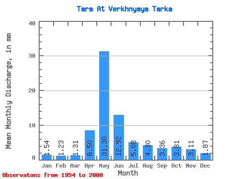
| Statistic | Jan | Feb | Mar | Apr | May | Jun | Jul | Aug | Sep | Oct | Nov | Dec | Annual |
|---|---|---|---|---|---|---|---|---|---|---|---|---|---|
| Mean | 1.54 | 1.24 | 1.30 | 8.50 | 31.30 | 12.92 | 5.08 | 4.30 | 3.36 | 3.81 | 3.11 | 1.87 | 77.94 |
| Standard Deviation | 0.70 | 0.34 | 0.34 | 7.42 | 20.58 | 11.68 | 5.12 | 5.09 | 3.19 | 3.13 | 2.60 | 1.14 | 43.97 |
| Min | 0.60 | 0.72 | 0.10 | 1.25 | 2.61 | 1.14 | 0.57 | 1.08 | 0.81 | 0.96 | 0.66 | 0.56 | 13.83 |
| Max | 4.46 | 2.29 | 1.97 | 31.35 | 68.56 | 52.26 | 22.41 | 27.17 | 15.14 | 12.64 | 13.19 | 7.16 | 206.21 |
| Coefficient of Variation | 0.45 | 0.27 | 0.26 | 0.87 | 0.66 | 0.90 | 1.01 | 1.19 | 0.95 | 0.82 | 0.84 | 0.61 | 0.56 |
 Return to R-Arctic Net Home Page