|
|
|||||||||||||||||
| Point ID: 7025 | Downloads | Plots | Site Data | Code: 11342 |
|
|
|||||||||||||||||
| Download | |
|---|---|
| Site Descriptor Information | Site Time Series Data |
| Link to all available data | |
| View: | Time Series | All |
| Units: | m3/s |
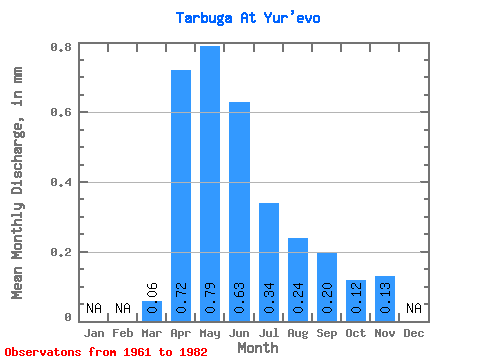
| Statistic | Jan | Feb | Mar | Apr | May | Jun | Jul | Aug | Sep | Oct | Nov | Dec | Annual |
|---|---|---|---|---|---|---|---|---|---|---|---|---|---|
| Mean | 0.06 | 0.72 | 0.79 | 0.63 | 0.34 | 0.24 | 0.20 | 0.12 | 0.13 | ||||
| Standard Deviation | 0.86 | 1.63 | 0.70 | 0.41 | 0.22 | 0.05 | 0.11 | ||||||
| Min | 0.06 | 0.02 | 0.00 | 0.01 | 0.00 | 0.00 | 0.16 | 0.04 | 0.13 | ||||
| Max | 0.06 | 2.77 | 5.56 | 1.85 | 1.11 | 0.52 | 0.24 | 0.20 | 0.13 | ||||
| Coefficient of Variation | 1.19 | 2.06 | 1.11 | 1.19 | 0.93 | 0.26 | 0.96 |
 Return to R-Arctic Net Home Page