|
|
|||||||||||||||||
| Point ID: 7011 | Downloads | Plots | Site Data | Code: 11313 |
|
|
|||||||||||||||||
| Download | |
|---|---|
| Site Descriptor Information | Site Time Series Data |
| Link to all available data | |
| View: | Time Series | All |
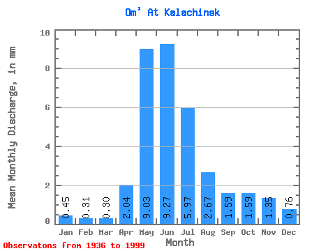
| Units: | m3/s |
| Statistic | Jan | Feb | Mar | Apr | May | Jun | Jul | Aug | Sep | Oct | Nov | Dec | Annual |
|---|---|---|---|---|---|---|---|---|---|---|---|---|---|
| Mean | 0.45 | 0.31 | 0.30 | 2.04 | 9.03 | 9.27 | 5.97 | 2.67 | 1.59 | 1.59 | 1.35 | 0.76 | 35.46 |
| Standard Deviation | 0.34 | 0.20 | 0.14 | 1.84 | 4.58 | 7.95 | 7.59 | 3.72 | 1.92 | 1.76 | 1.53 | 0.79 | 27.62 |
| Min | 0.09 | 0.06 | 0.08 | 0.36 | 0.73 | 0.21 | 0.03 | 0.02 | 0.20 | 0.27 | 0.10 | 0.12 | 3.01 |
| Max | 1.81 | 0.99 | 0.82 | 11.88 | 25.21 | 33.78 | 30.87 | 17.20 | 11.17 | 7.51 | 5.86 | 4.03 | 119.79 |
| Coefficient of Variation | 0.77 | 0.63 | 0.48 | 0.90 | 0.51 | 0.86 | 1.27 | 1.39 | 1.21 | 1.11 | 1.14 | 1.03 | 0.78 |
 Return to R-Arctic Net Home Page