|
|
|||||||||||||||||
| Point ID: 701 | Downloads | Plots | Site Data | Code: 07CE005 |
|
|
|||||||||||||||||
| Download | |
|---|---|
| Site Descriptor Information | Site Time Series Data |
| Link to all available data | |
| View: | Time Series | All |
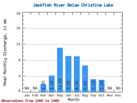
| Units: | m3/s |
| Statistic | Jan | Feb | Mar | Apr | May | Jun | Jul | Aug | Sep | Oct | Nov | Dec | Annual |
|---|---|---|---|---|---|---|---|---|---|---|---|---|---|
| Mean | 1.92 | 4.06 | 10.92 | 8.89 | 8.77 | 6.51 | 3.14 | 2.99 | |||||
| Standard Deviation | 0.77 | 2.02 | 15.04 | 6.28 | 5.86 | 6.42 | 2.02 | 2.06 | |||||
| Min | 0.50 | 2.19 | 1.12 | 1.26 | 0.95 | 0.95 | 0.52 | 0.76 | |||||
| Max | 2.84 | 8.30 | 54.60 | 22.50 | 22.42 | 23.46 | 7.19 | 7.79 | |||||
| Coefficient of Variation | 0.40 | 0.50 | 1.38 | 0.71 | 0.67 | 0.98 | 0.64 | 0.69 |
 Return to R-Arctic Net Home Page