|
|
|||||||||||||||||
| Point ID: 7008 | Downloads | Plots | Site Data | Code: 11308 |
|
|
|||||||||||||||||
| Download | |
|---|---|
| Site Descriptor Information | Site Time Series Data |
| Link to all available data | |
| View: | Time Series | All |
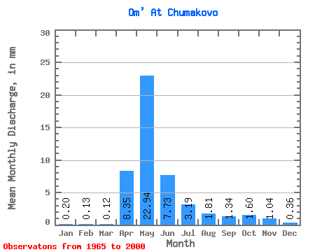
| Units: | m3/s |
| Statistic | Jan | Feb | Mar | Apr | May | Jun | Jul | Aug | Sep | Oct | Nov | Dec | Annual |
|---|---|---|---|---|---|---|---|---|---|---|---|---|---|
| Mean | 0.20 | 0.13 | 0.12 | 8.35 | 22.94 | 7.73 | 3.19 | 1.81 | 1.34 | 1.59 | 1.04 | 0.36 | 49.10 |
| Standard Deviation | 0.22 | 0.12 | 0.09 | 8.04 | 19.02 | 8.41 | 7.25 | 3.82 | 2.73 | 2.72 | 1.51 | 0.48 | 39.53 |
| Min | 0.02 | 0.01 | 0.02 | 1.03 | 0.68 | 0.12 | 0.05 | 0.04 | 0.04 | 0.07 | 0.06 | 0.04 | 4.22 |
| Max | 0.98 | 0.53 | 0.37 | 35.07 | 68.79 | 32.53 | 40.96 | 18.33 | 13.77 | 11.68 | 5.67 | 2.45 | 148.76 |
| Coefficient of Variation | 1.07 | 0.93 | 0.72 | 0.96 | 0.83 | 1.09 | 2.27 | 2.11 | 2.03 | 1.71 | 1.45 | 1.33 | 0.81 |
 Return to R-Arctic Net Home Page