|
|
|||||||||||||||||
| Point ID: 7005 | Downloads | Plots | Site Data | Code: 11291 |
|
|
|||||||||||||||||
| Download | |
|---|---|
| Site Descriptor Information | Site Time Series Data |
| Link to all available data | |
| View: | Time Series | All |
| Units: | m3/s |
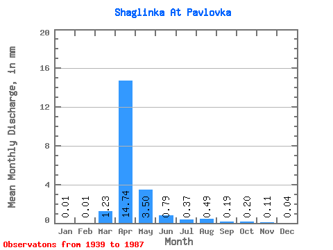
| Statistic | Jan | Feb | Mar | Apr | May | Jun | Jul | Aug | Sep | Oct | Nov | Dec | Annual |
|---|---|---|---|---|---|---|---|---|---|---|---|---|---|
| Mean | 0.01 | 0.01 | 1.23 | 14.74 | 3.50 | 0.79 | 0.37 | 0.49 | 0.19 | 0.20 | 0.12 | 0.04 | 53.67 |
| Standard Deviation | 0.02 | 0.01 | 2.52 | 12.52 | 3.16 | 0.87 | 0.47 | 1.78 | 0.33 | 0.18 | 0.11 | 0.03 | 16.73 |
| Min | 0.00 | 0.00 | 0.00 | 1.69 | 0.46 | 0.15 | 0.04 | 0.03 | 0.03 | 0.03 | 0.00 | 0.00 | 41.84 |
| Max | 0.05 | 0.03 | 9.14 | 57.47 | 18.36 | 5.57 | 3.02 | 12.38 | 2.31 | 1.19 | 0.55 | 0.13 | 65.50 |
| Coefficient of Variation | 1.45 | 1.14 | 2.05 | 0.85 | 0.90 | 1.10 | 1.27 | 3.62 | 1.73 | 0.94 | 1.00 | 0.80 | 0.31 |
 Return to R-Arctic Net Home Page