|
|
|||||||||||||||||
| Point ID: 7004 | Downloads | Plots | Site Data | Code: 11276 |
|
|
|||||||||||||||||
| Download | |
|---|---|
| Site Descriptor Information | Site Time Series Data |
| Link to all available data | |
| View: | Time Series | All |
| Units: | m3/s |
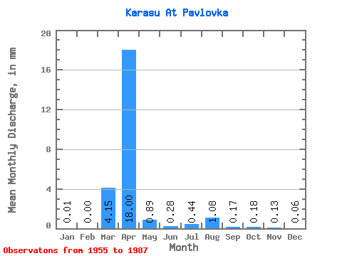
| Statistic | Jan | Feb | Mar | Apr | May | Jun | Jul | Aug | Sep | Oct | Nov | Dec | Annual |
|---|---|---|---|---|---|---|---|---|---|---|---|---|---|
| Mean | 0.01 | 0.00 | 4.15 | 18.00 | 0.89 | 0.28 | 0.44 | 1.08 | 0.17 | 0.17 | 0.13 | 0.06 | 25.52 |
| Standard Deviation | 0.01 | 0.00 | 4.98 | 11.49 | 0.93 | 0.38 | 0.73 | 3.73 | 0.19 | 0.14 | 0.12 | 0.05 | 1.40 |
| Min | 0.00 | 0.00 | 0.00 | 2.85 | 0.12 | 0.00 | 0.03 | 0.01 | 0.00 | 0.00 | 0.00 | 0.00 | 24.53 |
| Max | 0.03 | 0.00 | 15.21 | 47.54 | 4.87 | 1.90 | 2.73 | 18.71 | 0.99 | 0.64 | 0.41 | 0.14 | 26.51 |
| Coefficient of Variation | 1.73 | 1.20 | 0.64 | 1.05 | 1.34 | 1.66 | 3.45 | 1.14 | 0.82 | 0.93 | 0.95 | 0.06 |
 Return to R-Arctic Net Home Page