|
|
|||||||||||||||||
| Point ID: 6973 | Downloads | Plots | Site Data | Code: 11129 |
|
|
|||||||||||||||||
| Download | |
|---|---|
| Site Descriptor Information | Site Time Series Data |
| Link to all available data | |
| View: | Time Series | All |
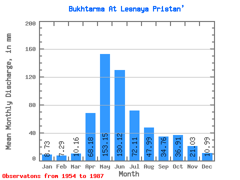
| Units: | m3/s |
| Statistic | Jan | Feb | Mar | Apr | May | Jun | Jul | Aug | Sep | Oct | Nov | Dec | Annual |
|---|---|---|---|---|---|---|---|---|---|---|---|---|---|
| Mean | 8.73 | 7.35 | 10.16 | 68.18 | 153.13 | 130.12 | 72.09 | 47.98 | 34.76 | 36.90 | 21.03 | 10.98 | 597.99 |
| Standard Deviation | 2.88 | 2.17 | 3.99 | 22.99 | 37.95 | 52.20 | 32.91 | 19.22 | 15.45 | 17.92 | 8.36 | 3.97 | 138.94 |
| Min | 3.03 | 4.01 | 6.23 | 16.86 | 94.11 | 42.88 | 24.78 | 19.17 | 14.95 | 15.32 | 9.18 | 3.15 | 345.59 |
| Max | 15.24 | 12.68 | 22.52 | 112.64 | 226.25 | 229.65 | 159.93 | 80.84 | 78.24 | 81.59 | 42.63 | 18.55 | 906.56 |
| Coefficient of Variation | 0.33 | 0.29 | 0.39 | 0.34 | 0.25 | 0.40 | 0.46 | 0.40 | 0.45 | 0.49 | 0.40 | 0.36 | 0.23 |
 Return to R-Arctic Net Home Page