|
|
|||||||||||||||||
| Point ID: 6948 | Downloads | Plots | Site Data | Other Close Sites | Code: 11037 |
|
|
|||||||||||||||||
| Download | |
|---|---|
| Site Descriptor Information | Site Time Series Data |
| Link to all available data | |
| View: | Time Series | All |
| Units: | m3/s |
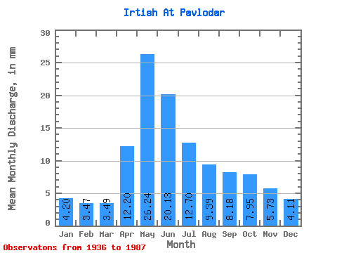
| Statistic | Jan | Feb | Mar | Apr | May | Jun | Jul | Aug | Sep | Oct | Nov | Dec | Annual |
|---|---|---|---|---|---|---|---|---|---|---|---|---|---|
| Mean | 2.79 | 2.33 | 2.32 | 8.11 | 17.45 | 13.38 | 8.44 | 6.24 | 5.44 | 5.29 | 3.81 | 2.73 | 77.53 |
| Standard Deviation | 0.95 | 0.83 | 0.64 | 2.71 | 4.29 | 5.67 | 3.84 | 2.36 | 2.22 | 1.76 | 1.47 | 1.14 | 16.18 |
| Min | 1.33 | 1.20 | 1.22 | 3.39 | 9.05 | 4.12 | 3.35 | 3.12 | 2.69 | 3.04 | 1.55 | 1.62 | 44.16 |
| Max | 5.24 | 4.71 | 3.78 | 14.94 | 27.67 | 24.56 | 19.88 | 12.39 | 13.93 | 12.24 | 7.68 | 6.71 | 113.70 |
| Coefficient of Variation | 0.34 | 0.36 | 0.28 | 0.33 | 0.25 | 0.42 | 0.46 | 0.38 | 0.41 | 0.33 | 0.39 | 0.42 | 0.21 |
| Other Close Sites | ||||||
|---|---|---|---|---|---|---|
| PointID | Latitude | Longitude | Drainage Area | Source | Name | |
| 7140 | "Irtish At Pavlodar" | 52.25 | -932209 | SHI | 2390.00 | |
 Return to R-Arctic Net Home Page