|
|
|||||||||||||||||
| Point ID: 6941 | Downloads | Plots | Site Data | Code: 10653 |
|
|
|||||||||||||||||
| Download | |
|---|---|
| Site Descriptor Information | Site Time Series Data |
| Link to all available data | |
| View: | Time Series | All |
| Units: | m3/s |
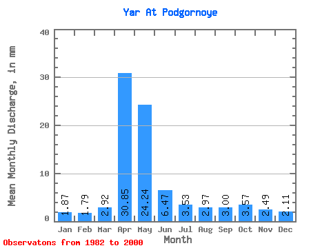
| Statistic | Jan | Feb | Mar | Apr | May | Jun | Jul | Aug | Sep | Oct | Nov | Dec | Annual |
|---|---|---|---|---|---|---|---|---|---|---|---|---|---|
| Mean | 1.87 | 1.81 | 2.92 | 30.85 | 24.24 | 6.47 | 3.53 | 2.97 | 3.00 | 3.57 | 2.49 | 2.11 | 92.15 |
| Standard Deviation | 1.15 | 0.75 | 3.34 | 19.94 | 9.95 | 3.48 | 1.63 | 1.35 | 1.86 | 1.90 | 0.68 | 0.79 | 31.99 |
| Min | 0.09 | 0.62 | 0.04 | 4.48 | 9.81 | 2.34 | 0.61 | 0.45 | 0.46 | 1.24 | 1.25 | 0.66 | 42.55 |
| Max | 3.64 | 3.36 | 13.24 | 83.99 | 45.20 | 13.87 | 5.92 | 5.51 | 7.50 | 7.53 | 3.83 | 3.34 | 141.80 |
| Coefficient of Variation | 0.61 | 0.42 | 1.14 | 0.65 | 0.41 | 0.54 | 0.46 | 0.46 | 0.62 | 0.53 | 0.27 | 0.37 | 0.35 |
 Return to R-Arctic Net Home Page