|
|
|||||||||||||||||
| Point ID: 694 | Downloads | Plots | Site Data | Code: 07CC001 |
|
|
|||||||||||||||||
| Download | |
|---|---|
| Site Descriptor Information | Site Time Series Data |
| Link to all available data | |
| View: | Time Series | All |
| Units: | m3/s |
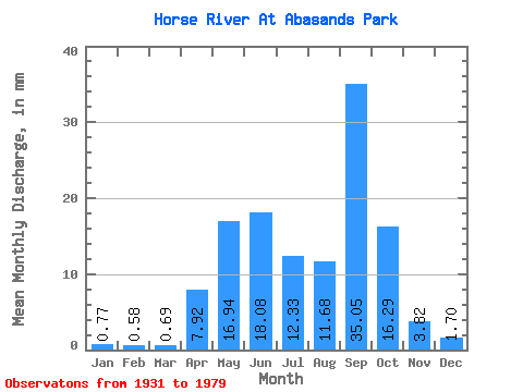
| Statistic | Jan | Feb | Mar | Apr | May | Jun | Jul | Aug | Sep | Oct | Nov | Dec | Annual |
|---|---|---|---|---|---|---|---|---|---|---|---|---|---|
| Mean | 0.77 | 0.58 | 0.69 | 7.92 | 16.94 | 18.08 | 12.33 | 11.67 | 35.05 | 16.29 | 3.83 | 1.70 | 128.22 |
| Standard Deviation | 0.38 | 0.25 | 0.33 | 5.00 | 11.72 | 10.11 | 6.27 | 10.46 | 25.93 | 6.38 | 1.82 | 0.66 | 17.34 |
| Min | 0.23 | 0.19 | 0.18 | 1.57 | 3.41 | 6.13 | 6.63 | 4.81 | 5.12 | 9.00 | 2.56 | 1.27 | 108.21 |
| Max | 1.17 | 0.85 | 1.00 | 13.75 | 24.14 | 29.33 | 18.48 | 27.03 | 50.74 | 20.87 | 5.91 | 2.46 | 138.65 |
| Coefficient of Variation | 0.50 | 0.43 | 0.48 | 0.63 | 0.69 | 0.56 | 0.51 | 0.90 | 0.74 | 0.39 | 0.48 | 0.39 | 0.14 |
 Return to R-Arctic Net Home Page