|
|
|||||||||||||||||
| Point ID: 6935 | Downloads | Plots | Site Data | Code: 10623 |
|
|
|||||||||||||||||
| Download | |
|---|---|
| Site Descriptor Information | Site Time Series Data |
| Link to all available data | |
| View: | Time Series | All |
| Units: | m3/s |
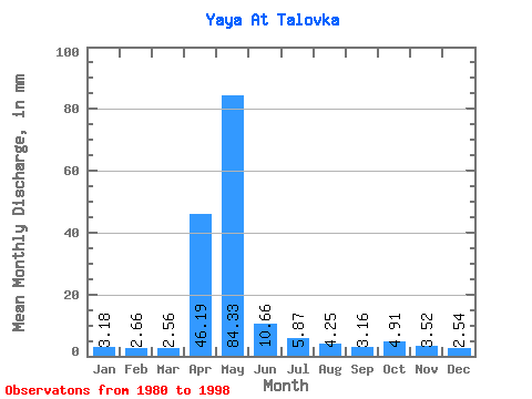
| Statistic | Jan | Feb | Mar | Apr | May | Jun | Jul | Aug | Sep | Oct | Nov | Dec | Annual |
|---|---|---|---|---|---|---|---|---|---|---|---|---|---|
| Mean | 3.18 | 2.69 | 2.56 | 46.19 | 84.32 | 10.66 | 5.86 | 4.24 | 3.16 | 4.91 | 3.51 | 2.54 | 171.83 |
| Standard Deviation | 2.10 | 2.00 | 2.02 | 30.38 | 46.73 | 8.41 | 6.68 | 5.76 | 2.58 | 4.04 | 1.86 | 1.47 | 42.38 |
| Min | 0.71 | 0.76 | 0.77 | 4.43 | 20.71 | 2.50 | 0.65 | 0.23 | 0.22 | 0.60 | 0.75 | 0.53 | 102.35 |
| Max | 8.07 | 7.47 | 7.49 | 83.69 | 161.32 | 36.48 | 26.33 | 23.62 | 8.81 | 16.39 | 7.93 | 5.81 | 270.86 |
| Coefficient of Variation | 0.66 | 0.74 | 0.79 | 0.66 | 0.55 | 0.79 | 1.14 | 1.36 | 0.82 | 0.82 | 0.53 | 0.58 | 0.25 |
 Return to R-Arctic Net Home Page