|
|
|||||||||||||||||
| Point ID: 6930 | Downloads | Plots | Site Data | Code: 10595 |
|
|
|||||||||||||||||
| Download | |
|---|---|
| Site Descriptor Information | Site Time Series Data |
| Link to all available data | |
| View: | Time Series | All |
| Units: | m3/s |
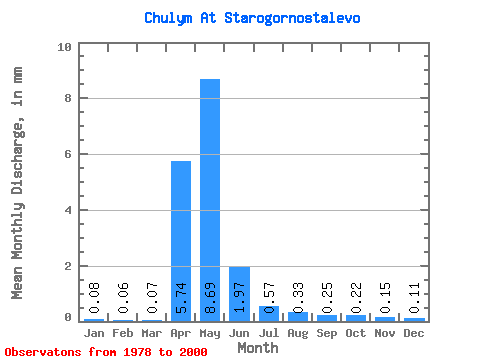
| Statistic | Jan | Feb | Mar | Apr | May | Jun | Jul | Aug | Sep | Oct | Nov | Dec | Annual |
|---|---|---|---|---|---|---|---|---|---|---|---|---|---|
| Mean | 0.08 | 0.06 | 0.07 | 5.74 | 8.69 | 1.97 | 0.57 | 0.33 | 0.25 | 0.22 | 0.15 | 0.10 | 18.21 |
| Standard Deviation | 0.02 | 0.02 | 0.02 | 4.28 | 12.45 | 3.21 | 0.59 | 0.33 | 0.21 | 0.18 | 0.10 | 0.04 | 19.35 |
| Min | 0.05 | 0.04 | 0.04 | 1.74 | 0.48 | 0.08 | 0.08 | 0.08 | 0.07 | 0.07 | 0.07 | 0.06 | 3.90 |
| Max | 0.12 | 0.11 | 0.13 | 13.97 | 48.21 | 12.35 | 2.49 | 1.46 | 0.70 | 0.74 | 0.42 | 0.18 | 79.75 |
| Coefficient of Variation | 0.23 | 0.29 | 0.31 | 0.74 | 1.43 | 1.63 | 1.03 | 0.98 | 0.85 | 0.82 | 0.62 | 0.34 | 1.06 |
 Return to R-Arctic Net Home Page